CEMML is highly capable in spatial analysis, including geographic information systems (GIS). We can provide development and management of databases, modeling, analysis, web application design, and digital and print cartographic products.
GIS and Spatial IT Services
Web Application Development
- Design and development of customized, web-based interactive map applications and viewers, including mobile applications for mission and program support.
- Design and development of web applications for Esri’s ArcGIS Online platform or customized deployment.
Spatial Analysis & Modeling
Creation of GIS model and map products using remotely sensed data, digital orthophotos, satellite imagery, and aerial photography.
- Use of spectral imagery and LiDAR to develop land cover, wetland delineation, and vegetation communities; model soil erosion, fire risk and behavior, biodiversity studies, floodplain analysis, climate change effects; analyze cultural/archaeological sites.
- Specific expertise in surface danger mapping and adept at operating specific U.S. Army systems in relationship to Integrated Training Area Management (ITAM) efforts.
Cartographic Product Creation
- Depiction of land conditions and installation restrictions to assist with mission and installation planning and decision-making.
- Products include, but are not limited to, military installation maps, National Environmental Policy Act maps, installation atlases and map books, biological assessment maps, Integrated Natural Resources Management Plan maps, and media-linked PDF maps.
- Development of U.S. National Vegetation Classification (NVC) maps at the alliance level, 100 and 500 year flood maps, wetland delineation, land cover, and other resource mapping are a few specialized capabilities.
Data Development & Standardization
- Development and management of complex databases.
- GPS and field data collection, geocoding, and on-screen digitization.
- Building of Esri ArcGIS ArcObjects/.NET compiled and Python-based script applications and tools.
- Expertise in complying with Spatial Data Standards for Facilities, Infrastructure, and Environment (SDSFIE).
Email GIS and Spatial IT inquiries to cemml@colostate.edu
Latest CEMML Stories
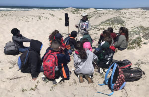
Sharing the beach: CEMML supports snowy plovers and communities in California
In 2020, Vandenberg Space Force Station and CEMML began providing educational programs at local elementary schools to spread awareness about the snowy plover, a rare migratory shorebird currently listed as threatened under the federal Endangered Species Act. Over 600 students have participated in the program since the program began.
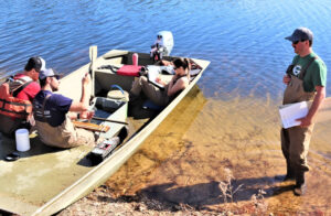
CEMML conducts surveys to aid fisheries management at Fort McCoy
Every year, watershed management biologists and specialists with CEMML, in partnership with Fort McCoy’s Directorate of Public Works Environmental Division Natural Resources Branch (NRB), hold fish surveys at Fort McCoy’s 10 lakes and ponds. Surveys are conducted using various methods to understand fish populations and the overall health of the waterways.
CEMML archaeological survey explores early 20th century history of Fort McCoy
An archaeological survey conducted by CEMML personnel in the summer of 2022 was initially meant to investigate the creation of several hundred concrete tent pads at Fort McCoy, Wisconsin. Research into the tent pads, dating from around the early 20th century, also unearthed additional information about other possible known archaeological features and sites around what is referred to as “Old Camp McCoy.”