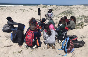
Integrated Training Area Management

CEMML teams work closely with installation Range Management offices to ensure that land management projects meet the requirements of training missions. CEMML’s Integrated Training Area Management (ITAM) expertise includes: Training Requirements Integration (TRI), Land Rehabilitation and Maintenance (LRAM), Range and Training Land Assessments (RTLA), Sustainable Range Awareness (SRA), and Geographic Information Systems (GIS) support.

ITAM Services

Training Requirements Integration (TRI)

  • Integration of land management objectives that support training missions with strategies to conserve natural and cultural resources.
  • Compliance with National Environmental Policy Act and other environmental laws to avoid restrictions on training.

Land Rehabilitation and Maintenance (LRAM)

  • Identification of LRAM projects needs and sustainable land management strategies and recommendations based on environmental conditions.
  • Soil stabilization and vegetation management to maintain, repair, and reconfigure areas that support military training and testing missions.
  • LRAM mitigation and compliance practices such as designing and installing approved projects in support of the Clean Water Act, buffer zones for wetlands, and protective caps for archaeological sites.

Range and Training Land Assessments (RTLA)

  • Range and Training Land Assessments, including identification of landscape, vegetation, and soil conditions that meet the training requirements of Mission Essential Task Lists, Programs of Instruction, and mission commanders.

Sustainable Range Awareness (SRA)

  • Production of natural and cultural resources awareness and outreach materials for military installations, such as customized graphics, brochures, wall calendars, and field cards.

Geographic Information Systems (GIS) Support

  • Expertise in spatial database management, analysis, cartography, custom programming, and remote sensing.
  • Development of military installation maps; mapping of LRAM projects; and GIS support for range operations, range modernization, and training missions.

Related Stories

Fish surveys conducted at Fort McCoy, Wisconsin

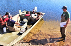
CEMML conducts surveys to aid fisheries management at Fort McCoy

Every year, watershed management biologists and specialists with CEMML, in partnership with Fort McCoy’s Directorate of Public Works Environmental Division Natural Resources Branch (NRB), hold fish surveys at Fort McCoy’s 10 lakes and ponds. Surveys are conducted using various methods to understand fish populations and the overall health of the waterways.
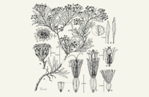
Read More »
Facebook
Twitter
LinkedIn